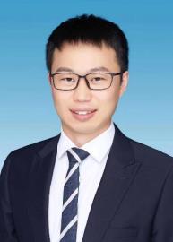
杨飞,博士、副教授,硕士生导师。
1991年生,本硕博均就读于武汉大学,获得武汉大学/英国诺丁汉大学联合培养博士。发表学术论文40余篇,其中一作/通讯SCI 23篇,EI 3篇,授权发明专利3项。主持国家自然科学基金、北京市自然科学基金、博士后基金各1项;主持各类国家重点实验室开放研究项目、国际合作项目、企事业单位委托项目20余项。获得国家注册测绘师、武汉大学学术创新一等奖、乐群学术之星、武汉大学优秀毕业生代表等。主讲本科生《GNSS原理与应用》、《数据结构》及研究生《GNSS地学应用》等课程。受邀担任IEEE TGRS、IEEE JSTARS、GPS Solutions、ASR、ESS等测绘领域SCI期刊审稿人。
电子邮箱:yangfei@cumtb.edu.cn 或 yangfei_gnss@163.com
研究方向:
北斗/GNSS高精度数据处理及应用
北斗/GNSS气象学(对流层建模/水汽层析)
北斗/GNSS反射测量及应用
多源观测的近地空间水环境监测与分析
矿区植被/大气参量反演及分析
代表性科研项目:
国家自然科学青年基金,地基北斗/GNSS水汽层析优化建模及稳定解算方法研究,主持
北京市自然科学基金,基于地基北斗/GNSS的北京冬奥赛区水汽层析反演研究,主持
博士后基金面上项目,参数自适应的地基GNSS水汽层析算法研究,主持
资源与环境信息系统国家重点实验室基金,融合多源数据的高时空分辨率大气水汽产品研制,主持
大地测量与地球动力学国家重点实验室基金,基于多源数据的地基GNSS水汽层析方法与应用研究,主持
煤炭资源与安全开采国家重点实验室基金,基于GRACE的地下水变化与矿区开采及生态修复相关性分析研究,主持
城市空间信息工程北京市重点实验室基金,基于多源观测的地基GNSS城市暴雨水汽时空变化研究,主持
近年代表性论文:
1.Yang, F.; Gong, X. et al. GNSS water vapor tomography based on Kalman filter with optimized noise covariance. GPS Solutions, 2023, 27, 181.
2.Yang, F.; Sun, Y. et al. Assessment of tomographic window and sampling rate effects on GNSS water vapor tomography. Satellite Navigation. 2023, 4, 7.
3.Sun, Y.; Yang, F.*; Liu, M. et al. Evaluation of the weighted mean temperature over China using multiple reanalysis data and radiosonde. Atmospheric Research. 2023, 285, 106664.
4.Sun, Y.; Yang, F.*; et al. Spatial-temporal variation analysis of water storage and their impacts on ecological environment in high-intensity coal mining areas. Land Degradation and Development, 2023, 34(2): 338-352.
5.Yang, F.; Wang, L. et al. A weighted mean temperature (Tm) augmentation method based on global latitude zone. GPS Solutions, 2022, 26, 141.
6.Yang, F.; Guo, J. et al. GGTm-Ts: a global grid model of weighted mean temperature (Tm) based on surface temperature (Ts) with two modes. Advances in Spaces Research. 2022, 71(3): 1510-1524.
7.Yang, F.; Wang, J. et al. The Impact of Human Activities on Net Primary Productivity in a Grassland Open-Pit Mine: The Case Study of the Shengli Mining Area in Inner Mongolia, China. Land 2022, 11, 743.
8.Yang, F.; Wang, J. et al. Assessment of the Water Vapor Tomography Based on Four Navigation Satellite Systems and Their Various Combinations. Remote Sensing. 2022, 14, 3552.
9.Li, J.; Guo, T.; Yang, F.*; et al. The fractional vegetation cover (FVC) and associated driving factors modelling in mining areas. Photogrammetric Engineering and Remote Sensing. 2022.
10.Yang F., Guo J. et al. A Regional Zenith Tropospheric Delay (ZTD) Model Based on GPT3 and ANN. Remote Sensing. 2021, 13, 838.
11.Yang F., Guo J. et al. A Global Grid Model for Calibration of Zenith Hydrostatic Delay. Advances in Space Research. 2021, 68, 3574-3583.
12.Yang F., Guo J. et al. Assessment of the Troposphere Products Derived from VMF Data Server with EAR5 and IGS data over China. Earth and Space Science. 2021, e2021EA001815.
13.Yang F., et al. Establishment and Assessment of a ZWD Augmentation Model. GPS Solutions. 2021, 25: 148.
14.Yang F., Meng X. et al. Development and Evaluation of the Refined ZTD models. Satellite Navigation. 2021, 2: 21
15.Yang, F., Guo, J. et al. A GPS water vapor tomography method based on a genetic algorithm. Atmos. Meas. Tech. 2020, 13, 355–371.
16.Yang, F., Meng, X. et al. The Influence of Different Modelling Factors on Global Temperature and Pressure Models and Their Performance in Different ZHD Models. Remote Sens. 2020, 12, 35.
17.Yang, F., Guo, J. et al. An improved weighted mean temperature model based on GPT2w with Tm lapse rate. GPS Solutions, 2020, 24, 46.
18.杨飞. 地基GNSS反演水汽空间分布关键技术研究. 测绘学报. 2022, 51(3): 470. (EI)
19.杨飞. GNSS大气平均温度经验模型精化方法的建立和分析. 测绘学报, 2022. (EI)
20.杨飞. 基于GRACE的黄河流域陆地水储量时空变化研究. 煤田地质与勘探. 2022, 50(4): 106−112. (EI)
奖项:
全国老员工测绘学科创新创业智能大赛,科技论文竞赛大赛二等奖/测绘程序设计竞赛一等奖,2023年
全国老员工测绘学科创新创业智能大赛,科技论文竞赛大赛一等奖、二等奖各1项,2022年
全国高等学校老员工测绘程序设计竞赛二等奖、虚拟仿真数字测图二等奖,2021年
全国高等学校测绘类专业青年教授讲课竞赛/GNSS原理与应用二等奖,2022年
中国测绘学会PIE遥感与地理信息一体软件二次开发大赛一等奖,优秀指导老师,2021年
北京老员工虚拟仿真测图技能大赛一等奖,优秀指导老师,2022年
北京老员工虚拟仿真测图技能大赛特等奖,优秀指导老师,2021年
优秀本科毕业论文一等奖(2023年)、二等奖(2021年),指导老师
青年教师教学优秀奖,2022年
北京高校优秀本科育人团队,2021年